

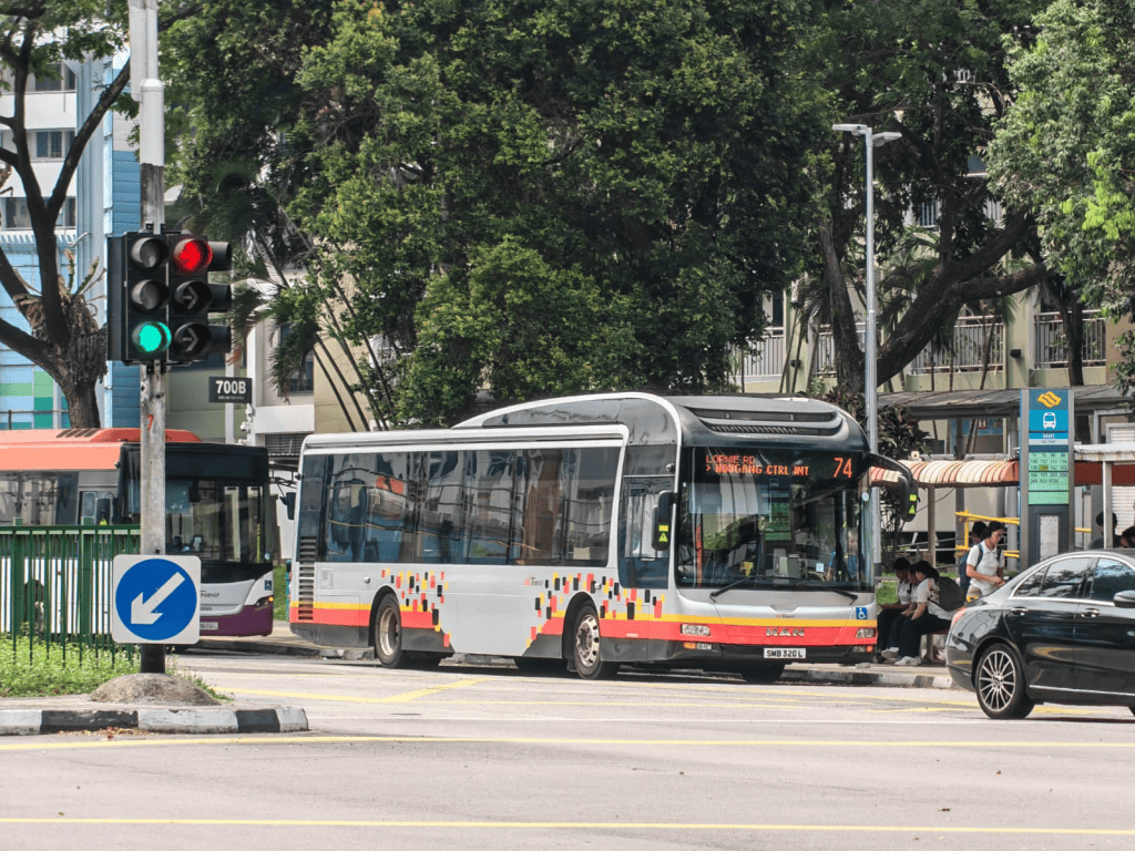
This post had been sitting around in my drafts for about two years or so by this point, but the nice thing is that these two years have seen enough developments in local bus planning that serve as real-life applications of the theory espoused in this post.
Also a disclaimer: this post is intended to inform you of how the trade-off between access, coverage and speed shapes bus planning. I can’t say I’m not inclined towards any particular school of thought, but this post does not come with the intent of evaluating the superiority of any particular choice made in these trade-offs. The illustrated model used in this post is also intended to convey the abstract idea of the express-coverage dilemma and different possible workaround approaches, and is meant to help you understand the implications of each option in the real world.
Thought experiment: Suppose you’re a planner for an unspecified public transit agency, and you’re tasked with offering express bus connections for five towns located along an expressway.
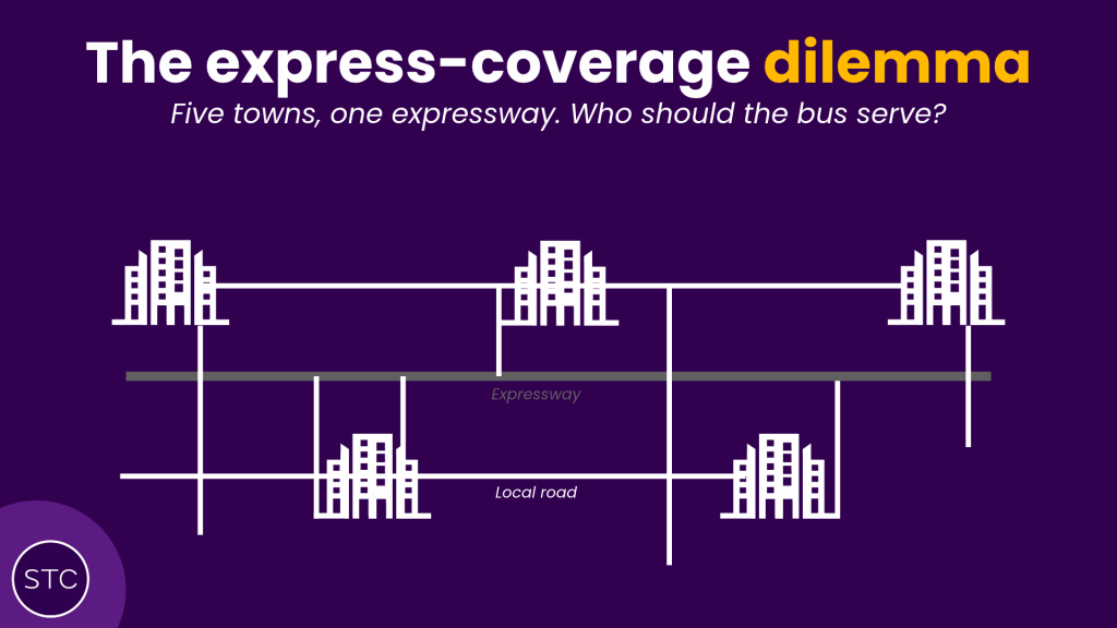
Of course, as typical humans do, residents in all five towns naturally want the bus to serve their town. As the planner, situations like these will pop up time and again as bus options are being considered to link towns strung along expressways. This is more pronounced for expressway routes, but frankly all bus services incorporating long, non-stop segments will encounter this problem to some extent.
Disclaimer: For the first part of this article, “express” services will refer to a planning framework similar to existing bus planning in Singapore, where the bus plies a local-stop segment in a town before running nonstop on the expressway to the next town. To clarify in light of our earlier post on distinguishing express as a concept from the Express branding.
Without assuming any central point of primacy (eg. a regional center or CBD) along the corridor, the instinct to provide the fastest possible bus connection would simply be to string a route serving the two extreme ends of the expressway, bypassing the three towns in between.
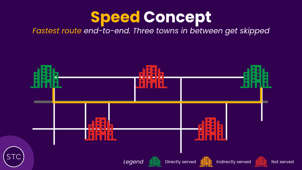
For reasons that may relate to more centrally-located towns tending to have larger populations, such an approach might quickly find yourself in the crossfire of residents living in the three towns skipped in between. (Read to the end: there are ways to avoid this, at different costs of course)
On the other end of the spectrum focused on providing access to all, the resulting route serves all five towns, but at the cost of speed — one wonders if there’s even any expressway sector left worth plying after all the detours made in the five towns, as shown below:
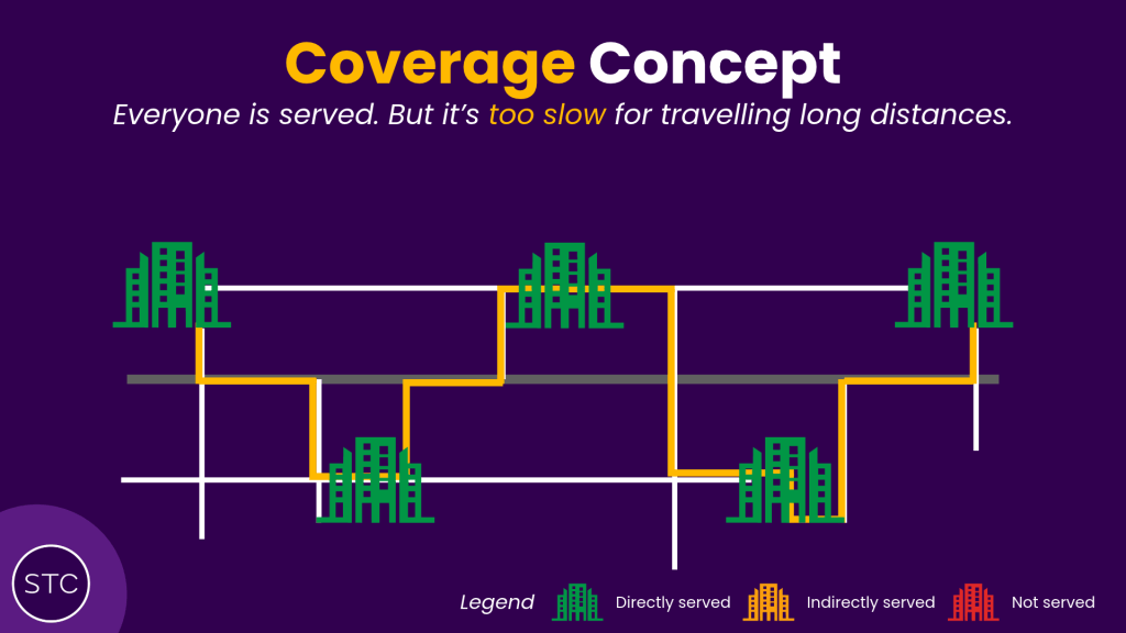
It would be barely faster than a regular trunk route plying on regular roads, if the limited expressway sectors could even provide any travel time advantage over being stopped at traffic lights.
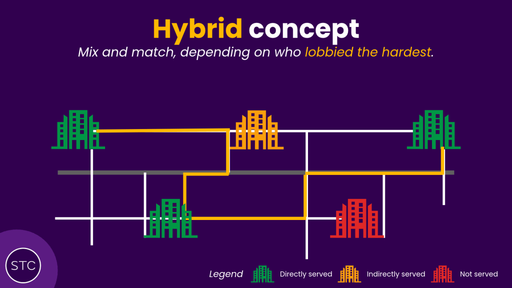
With this being a multi-factorial tug-of-war battle between many different stakeholders (residents of all five towns, MPs, business owners, and potentially even the bus operators themselves), the most likely outcome of who gets served by this route and who does not, is usually somewhere between both extremes listed above: the bus would ply some towns, while using the expressway to skip others, depending on who prevails in the debate of the day.
The express trade-off
“I can make the best bus route, but that means it will be very slow because it has to stop everywhere”
*Disclaimer: the Minister doesn’t consider transfers as part of this quote.
~Jeffrey Siow, 2025 (Source)
Demonstrated above is the trade-off between speed and coverage. Within the existing framework of express bus planning, these two parameters exist in opposition to one another, where improving the coverage of an express service in more towns requires sacrificing short travel times that an express bus service can potentially deliver.
Especially in the context of limited bus resources available (particularly in manpower, because we haven’t figured out automation for full-sized buses yet), this trade-off is particularly critical for one very important factor: how many people you can reach directly determines how well-used your bus service will be. Skipping over too much catchment directly hits potential ridership, making it less useful than a local-stopping trunk service that fully covers all possible residents and amenities located physically along the bus route. When an express route is designed too narrowly to only serve a very small group of people due to a small local segment, or an overly niche catchment, this is also known as the trap of overspecialisation, which general transit planning tries to avoid because ridership is built on the same bus or train being useful to many different travel needs.
But there’s a counterweight to the above argument too: dual pressures from travel time targets (such as LTMP 2040’s “45-minute city”) or the presence of an activity node (comprising amenities such as employment, education, or recreation) at one end of the line build a compelling case to introduce express service skipping some towns or parts thereof to provide faster and more direct journeys. To the extent that all-stopper local bus services add unnecessary travel time and make destinations beyond acceptable range of reach, designing a bus service pushed further in favour of coverage will discourage ridership from long-distance passengers.
In Singapore where the built form is sufficiently dense such that these amenities can be found almost anywhere, both the coverage and speed factors of bus route design are engaged in a constant tug of war against each other that determines the eventual ridership of the service. Because these comparisons are also heavily influenced by factors such as location, alignment and even fares (think 985 vs 506), there is no concrete math here to decisively determine how far the pull and push factors of coverage and speed each attract or repel potential riders from a bus service. No magic formula here, unfortunately! (Or maybe there is, but it’s too complex and we aren’t looking hard enough.)
Consider the example of bus services 178 and 187. Both ply routes between Woodlands and Bukit Panjang (and eventually on to Boon Lay, but their routes completely diverge past this point) that roughly parallel the North-South MRT line. While 187 skims past Marsiling and uses the express BKE route to reach Bukit Panjang, 178 takes a longer, local-stop route that also includes additional coverage deep inside Marsiling estate, the Woodlands train checkpoint, and industrial estates along Woodlands Road that the express 187 option all does not serve. Does this additional coverage of amenities translate to higher ridership for 178 compared to 187?
Not really, but with a few caveats. Because direct long-haul travel between Bukit Panjang and Woodlands makes up a stronger ridership pool than specific commuter groups, the general trend is that 187 is more heavily used, despite skipping over all the additional catchment 178 serves, and this is reflected in the deployments — 187 deploys more double-decker buses than 178 does.
However, ridership on 178 does surge, but it is highly conditional. Woodlands Checkpoint is the main variable here — 178 is another alternative to cross-border buses 160 and 170 for passengers who may choose to enter the checkpoint by foot, and cross-border demand alone can tilt the balance entirely especially during peak times. Besides that, demand on this sector of 178 is largely confined to niche time periods that correspond to either work timings of the factories along Woodlands Road, or the migrant workers living in the dormitories there. Generally however, 187 still does better in ridership terms. This is an example where long-distance demand generally wins out due to weaker intermediate catchment, with speed being the preferred route design element.
Now consider the case of services 52 and 74, which both cover the same general direction between the Marymount area (think Eunoia JC) and the Clementi Road school belt. With service 74 running the length of Bukit Timah Road between Botanic Gardens and Beauty World while 52 plies the faster PIE route, it is tempting to think that the faster route might enjoy higher ridership here too.
Except it’s the complete opposite this time: bus service 52 operates at measly 15-minute intervals throughout the day compared to 74 running every 10 minutes (offpeak) or better. Bus deployments further confirm this, with less than half of 52’s fleet being double-deck, compared to the overwhelming majority on 74.
What’s different? Besides just Clementi Road, Bukit Timah Road is another major education belt home to a number of prestigious schools (contrary to popular belief, a significant proportion of their students also use public transport too!), and a generous smattering of condominium apartments among the landed single-family houses that come to mind for the area. These schools with large student populations numbering in the thousands each contribute to steady additional ridership that 52 misses out on when bypassing the entire area. A strong catchment base skipped by 52 contributes to the slower route enjoying significantly higher ridership in this case.
*During off-peak hours, 74 tends to fly through Bukit Timah Road with the stops generally empty. As 74 is more frequent than 52, it might even be faster to take 74 from the west to the Bishan / Ang Mo Kio area, once waiting time is also factored in!
Of course, the comments are writing themselves already about how the above scenario of an express bus having to pick and choose between five towns on an expressway is unrealistic, so here’s the next part that’s more interesting: the numerous “workarounds” to the core speed-coverage tradeoff. Bad news: they come with their own set of trade-offs too, just not as obvious as the initial route-based one.
车海战术
Vaguely translated to “bus-wave tactics”, this is the consequence of the most common workaround to the express-coverage dilemma: simply introducing more routes to provide adequate coverage on each segment. This usually involves the assumption of a point of primacy somewhere along the express corridor, where everyone across the whole corridor is trying to go to the same area at once. The best real-world reflection of this is the City Direct express bus system that operates during the peak periods. Centered upon the select few corridors in the CBD, what the City Directs really do is to provide express connectivity to most housing estates located near expressways, with multiple routes branching off the same express corridors to maximise coverage.
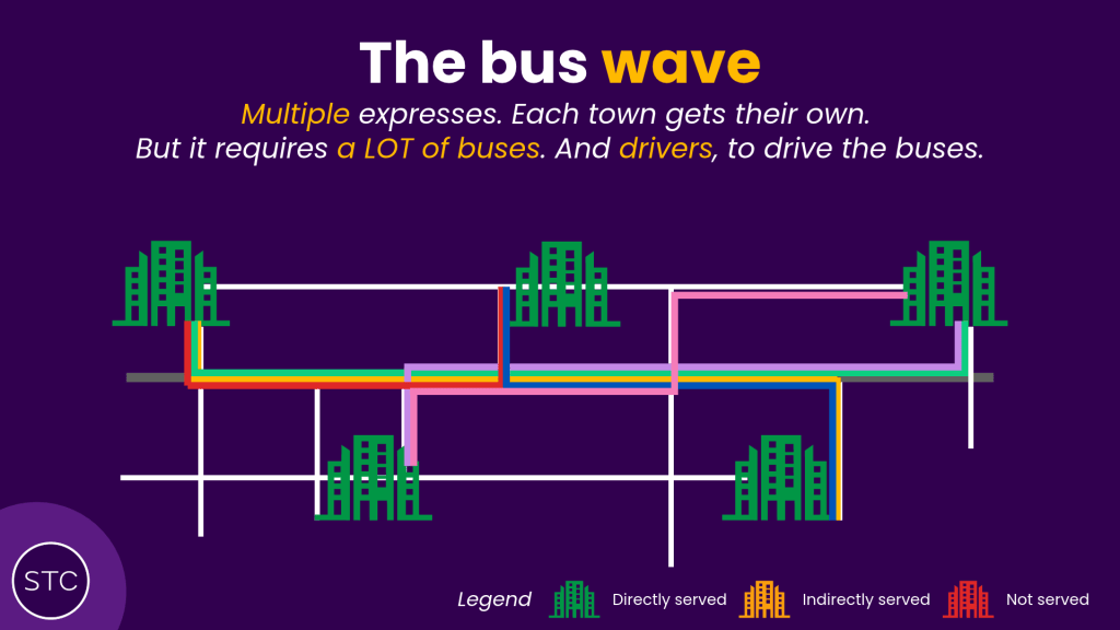
The tradeoff is apparent: operating multiple routes to cover express connectivity to every single town costs significantly more to operate in resources and manpower needed. Full-day express routes to the city do exist (think: 502, 518), but if every City Direct ran like them they’d probably be the size of two BCM bus packages (the current total is 14) alone. To make this resource utilisation more reasonable the CDS routes only operate a few one-way trips during peak hours, and even so thanks to the recent massive additions under BCEP the strain on limited bus resources is showing. Limiting the service span to keep things reasonable, ironically also reduces the general usefulness of these express services. This is precisely the phenomenon of overspecialisation talked about earlier, and the core express-coverage dilemma explains why express routes lend themselves towards this fallacy more often than other route types.
It’d be nice if we could commit an infinite fleet size and an infinite manpower pool towards providing boundless express connectivity for all. Nevermind the fact that a good number of these peak expresses aren’t performing very well despite adequate time given to build demand — they’re also being introduced at the cost of other connectivity needs that also need to be met with the same shrinking pie.
The silver bullet, BUT…
A new route type (to Singapore, at least) that this site actively advocates for implementation is known as rapid-stop services. Compared to express services that run faster because of non-stop segments, rapid services maintain a consistent stop interval, just longer, similar to how a MRT line would function. By serving more destinations and being useful to a greater diversity of commuter profiles, they are the alternative route design to avoid the overspecialisation trap express routes usually fall into, and this also means they can be more feasibly operated throughout the day.
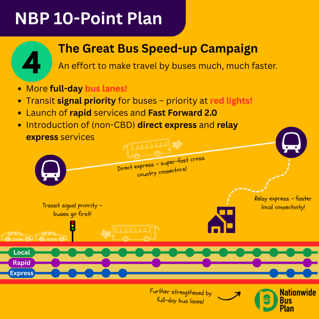
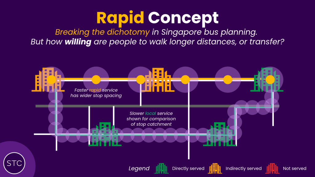
Rapid-stop routes were specifically designed to get around the coverage tradeoff that comes with express services, by enabling in-between towns that expresses would otherwise skip to also be served, without losing the benefit of higher average speed than an all-stop local service can manage. This comes with one big trade-off that some may be less willing to accept than others: the wider stop spacing on rapid services means fewer residents in each town are in direct walkable distance from the rapid stop. Sure, the rapid service being faster means each stop has a slightly larger walkshed than in an otherwise local-stop arrangement, but the larger stop spacing means fewer such stops exist. If transfers (from local services) and slightly longer walking distances are things that the community is allergic to, this solution may be less easy to stomach than thought.
As with the express-coverage dilemma mentioned above, this specific problem concerning access to routes with longer stop spacings is another topic to cover altogether. Tentatively, I’d call it the “rapid-access dilemma”. This is why you should never label a local bus service as a “duplicate” of the MRT!
For rapid services designed to ply non-expressway roads to maintain catchment while offering speed improvements, caution must also be taken to ensure beefy bus priority measures are in place as well. It wouldn’t make sense for these rapid services to be stuck in traffic on the general road network, either. Unfortunately, when it comes to the topic of bus priority in Singapore, we seem to treat it as an ornament, and not a road infrastructure necessity.
What LTA thought was BRT, circa 1988
There’s a precursor to the upcoming TPE bus stops being built along an active expressway: the AYE has also featured expressways along most of its length since its inception in 1988, converted from bus stop provisions along the local roads the expressway replaced. Positioned at intervals slightly wider than usual but still distinctively with the “local-stop” pattern, these bus stops aim to retain the coverage to homes, schools and offices located along the AYE after the expressway was built.
It’s a transformative way of providing express service (by virtue of the expressway generally having fewer traffic lights to stop at, even if you’re going through the slip road method like the AYE), particularly because you don’t have to exit the expressway and get caught in slow-moving traffic to serve town catchment along the way, which means the express route in question can run a reasonably straight route generally clear of obstruction.
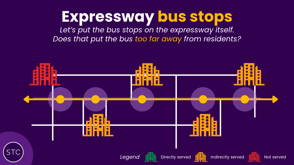
A particularly notable case of this is bus service 97, which plies almost the full length of the central AYE corridor between Jurong East and Alexandra as part of its larger route between Tengah and Marina Center. Its peak express variant (97e) runs the full length of the AYE into Cantonment, skipping Alexandra and HarbourFront.
The big caveat here is that catchment is highly limited compared to any of the other solutions being employed above: effective catchement of expressway bus stops is restricted to smaller zones directly adjacent to the expressway, with the latter also forming a barrier towards maximising useful coverage from the bus stop. Where expressways were also designed as primarily car-centric infrastructure, the hassle of crossing these expressways also shrinks how much people think these expressway bus services really serve, as opposed to routes with stops within the heart of housing estates. This can be a double-edged sword, and 97/e itself is a manifestation of both sides of the coin as far as expressway bus stops are concerned.
Not so long ago, 97/e began only from Jurong East and ended in the city, meaning the vast majority of the route exclusively served the AYE bus stops only. Despite passing between Clementi and West Coast estates, as well as between NUS and SP/ACSI/former SIT/Science Park, the AYE alignment was not conducive to strong ridership on 97 compared to other AYE bus services that branched off the expressway to directly serve these destinations. At some point it was thought this route was on the brink of rationalisation, similar to the fate that befell 506 and 852 from 2022 onwards. With route information of the Tengah extension absent from LTA Datamall, ridership statistics in April reflect this weak pre-extension ridership pattern.
Turning the fortunes of this bus service around was the 2025 extension to Tengah, which saw it operating effectively as a semi-express, full-day version of CDS 674 connecting Tengah to the city and other towns enroute. Anecdotally, it’s now a very well-used service particularly during the peak hours, with the partial single-deck fleet being deemed insufficient to meet demand. No concrete numbers yet, but we do expect a significant increase when results for peak express ridership are checked again for October. Remember however: these ridership improvements are hard carried by Tengah, and specifically its lack of rail connectivity putting the entire weight of long-distance connectivity on the sole long-haul trunk service in the town. In that respect, 97/e today is full less because of the catchment along Clementi and Kent Ridge, and more thanks to the long-distance Tengah – CBD travel pattern.
The Adelaide Method
In the current political climate, this is probably the least desirable option to take. Expanding upon the previous point on expressway bus stops having limited catchment, one possible remedy involves operating feeder routes connecting towns to expressway bus services, much in the same way as you’d expect a feeder bus to expand the reach of MRT stations. On some “closed” busway systems around the world such as Cambridge and Adelaide, this is done for stations located midway along the busway where buses cannot enter or leave freely unlike on more “open” systems. Connecting bus services are provided, grade-separated from the main busway, to reach rural areas located away from the corridor. This enables the expressway bus to really focus on direct, high-speed travel without meandering off to serve areas located away from the expressway alignment.
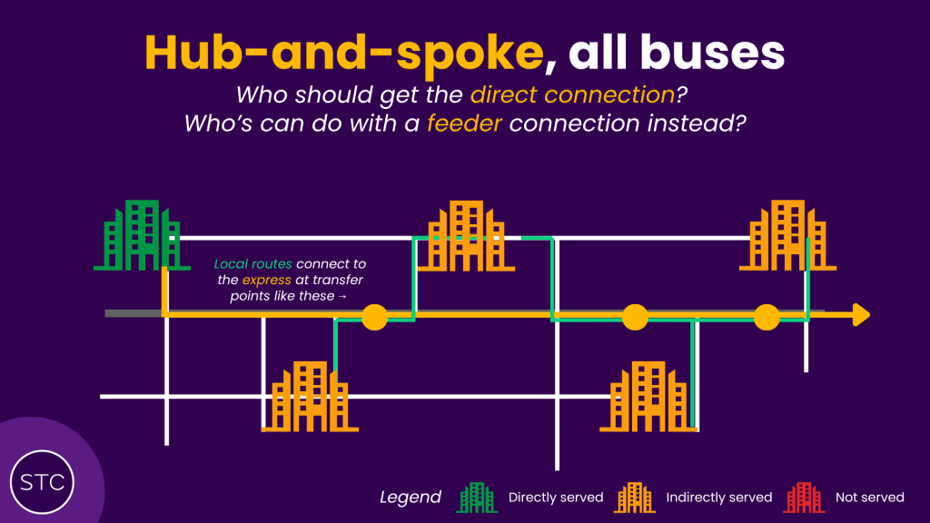
Whether this approach is desirable depends heavily on attitudes towards transferring during public transport journeys, particularly for buses. With past bus rationalisation exercises reducing bus services, being asked to transfer between buses without other major improvements made is unlikely to be a popular choice, particularly if loud MPs want to push greater emphasis on one-seat rides which BCEP planning is more inclined towards. What’s doable barring those however, is to set up such transfers such that they occur at the same stop, and are well-timed to reduce waiting for passengers. This arrangement technically already exists today at the famed Trellis Towers bus hub along the PIE:
Here, express-like services along the PIE (think: 151, 506, 985) interact with connecting bus services serving Thomson, Toa Payoh, Balestier and the city, with convenient same-stop transfers as well. It also got recognised as a major waypoint displayed on bus arrival screens recently too!
But who wins and loses?
Real-world bus planning is unlikely to come down to having a singular route manage competing demands from multiple towns along an expressway corridor all at once, and given the built density of Singapore’s towns the justification for multiple (but not too many ahem CDS) express routes down the same corridor is definitely present.
Each end of the spectrum between speed and coverage discussed above, alongside many of these “workarounds”, is a potentially valid option for satisfying high-speed public transport connectivity where rail does not, and cannot exist yet. With more discourse recently around how shortening travel times on public transport is an urgent need to fit decentralisation goals, the pressure to add more express service will mount, and part of it is already being expressed (pun not intended) in the BCEP’s efforts in introducing the 45x-numbered “limited stop” expresses and new CDS routes.
The important thing to remember is however that local bus connections continue to remain important, and will still have to be supplied in the future. With a shrinking manpower pie, whether it remains appropriate to continue employing the “bus-wave” tactic to ramp up express bus service is suspect, particularly when the cost is likely measured in reduced service levels for other commuters. In terms of the situation, the ECD becomes relevant especially if we intend to embark on investing in buses, even if as a mere stop-gap before much-needed rail connectivity slowly arrives decades down the road, simply because we may not be able to afford as many new express routes without destroying existing bus service levels. (The recent new route 873/M’s setup already indicates a shortage of either buses, or drivers, or both needed to launch even more new BCEP routes)
Actual rollout of an expanded express bus program in Singapore is more feasibly headed in the direction of building a more hub-and-spoke style network around a select group of long-haul super-express buses plying the expressways, to unlock their potential for public transport. In some cases, this can tap on existing expressway routes, and there’s an even wider range of options available for connecting routes to towns that these expresses are unable to directly serve, courtesy our highly-duplicative legacy bus network still with significant redundancy built in. Where the debates would be more fruitfully directed would be deciding which towns are more deserving of a direct connection on these express bus lines, and which could suffice with well-enhanced connecting routes at expressway transfer points.
A slice of the pie
Take Singapore’s longest expressway, the Pan-Island Expressway for instance:
Spanning the length of Singapore from Upper Changi to Tuas Basin, the PIE remains the critical east-west traffic artery for fast travel across the island by car. Largely completed by 1993, there remains no public transport alternative that offers the same fast east-west travel the PIE does for cars, with expressway bus services offering limited coverage outside the core Jalan Toa Payoh section. Located along it are many towns that would stand to benefit from an express bus connection along the full length of the PIE. The CRL exists yes, but that’s not finishing before the end-2030s, and still doesn’t meaningfully serve many of the towns located along the PIE to make a difference, as far as travel times on public transport are concerned.
Not every town is built the same however. Along the PIE one would find the big “anchor” towns that define place across the country, such as Tampines, Bedok, Toa Payoh and Jurong West. Even if not officially defined as regional centers by URA, these towns are to some extent, the center of gravity locally due to the presence of increased amenities there. Public transport connectivity is also relatively stronger in these towns, especially as these likely were established first, in an era where bus interchanges defined the nodes of public transport in Singapore. Typical planning of express service, which is ridership-oriented, tends towards prioritising these areas for express service, for purposes of best returns on served catchment area.
Then there are the smaller towns where public transport connectivity is more lacking, but are conveniently located near these expressways holding great potential for express bus service. Along the PIE, Simei and Pioneer are two such examples of underserved satelite towns that really deserve better in public transport planning. Due to their smaller size and other unfortunate geographic factors, these towns are usually also the most susceptible of falling into the cracks of transport planning goals that fail to account for the whole of the people, such as the 90% KPI for LTMP 2040’s 45-minute city goal.
With rail planning also equally likely to neglect these areas, a mitigating strategy is a needs-based express bus planning approach, where direct connections on express services prioritise these areas first to bring about the greatest reductions in travel time needed for them to enjoy the same convenience on public transport as their peers in regional centers.
Last but not least, there’s also the areas that are predominantly used for employment (a similar principle holds for education, but not quite). These are places that demand really fast journeys during peak hours… and then next to none outside them. But people still do travel in these areas! Along the PIE, areas such as Kaki Bukit, Beauty World (proximity to Bukit Timah, Clementi Rd and NUS) and Tuas would be such locations with more peak-oriented demand. How can express bus service be adequately provisioned for these demographics, without coming at a cost to other commuters travelling during the same time periods?
For most of the PIE, any form of express bus service introduced already represents a great improvement in enabling public transport to use the same infrastructure than enables fast car journeys. The more critical question to solve is how to arrange within that expanded coverage, the service needed to maximise the utility of what little we can afford for expanded express bus service.
The core question
Now back to your hypothetical role as a bus planner. The expressway is already there, and likely predates your career by decades. Entire towns have developed along the expressway, and all of them could stand to benefit from a new express bus service. As you’re likely bound by existing frameworks of express bus planning, remember: the faster you make the bus go, the more people it’s going to skip.
But make it too slow, and it erodes the purpose and benefit of an express route, with the added drawback of a hefty fare surcharge on passengers. There are workaround solutions, but the resource-prudent choices would all require having somebody walk further, or make a transfer from a local service. Which areas are more deserving of an express bus connection? Your call.
Interested in building a better future for Singapore’s transport? Join the STC community on Discord today!


Leave a Reply