
(note, as we transition to the new oneSTC site, this is the first post I am making using a numerical chapter formatting, please comment whether y’all like this format, thanks! ~LemonNarc)
Chapters:
- A Quick Introduction
- Public Transport Connections (Train)
- Public Transport Connections (Bus)
- Bicycle usage
- General State of Urbanism
- Property Prices
- The bad
- Summary
1. A Quick Introduction to the wholly milked meme
To anyone that has stayed in Singapore for…at least 2 years? We have probably heard of the long running Singaporean meme; East Side Best Side!

Often, Easties would always boast to our Western neighbors umpteen times over the most minor, to significant benefits, from allegedly having better food, to more undisputable pros such as enhanced access to key facilities/destinations (e.g. Changi Airport). It has already been done to death of blabbing on the higher “standard of living” the rat-race culture of this island is striving towards.
But netizen squabbles aside, it is worth pondering over: is the above statement actually true? Read on, as I, a person who always frequents the gargantuan Eastern town for many errands, elaborate on my findings.
2. Public Transport Connections (Train)
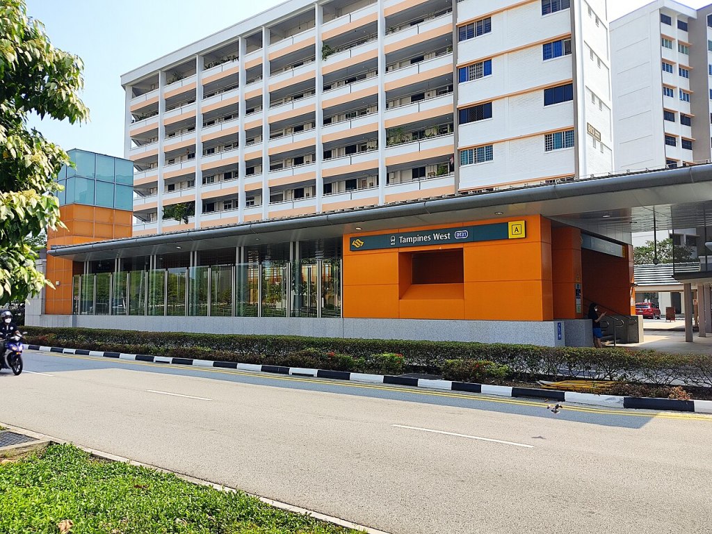
Tampines town is difficult to compete with in this regard, as of 2024, it is one of those expectional towns to have NOT one, NOT two, but at least 3 MRT Stations currently serving the humongous population.
I have never seen a town in Singapore with this much MRT spam. And best of all, it won’t end there! Upcoming in the 2030s, would be another station, Tampines North, connecting the “transit town” with the shiny, promising CRL.
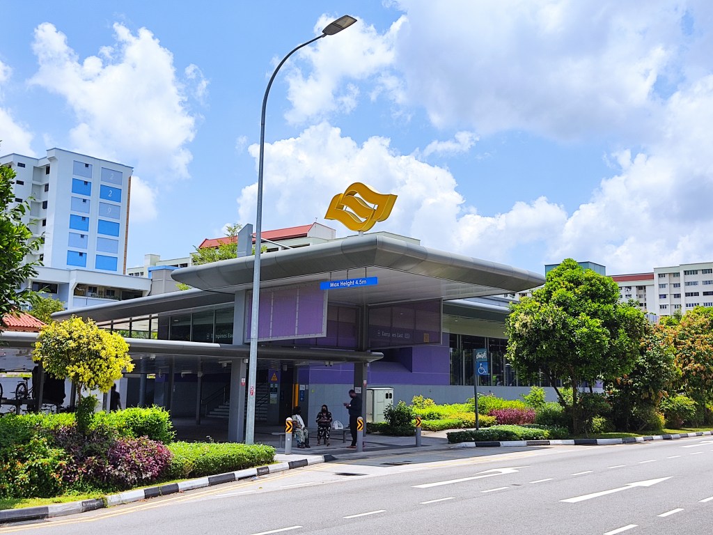
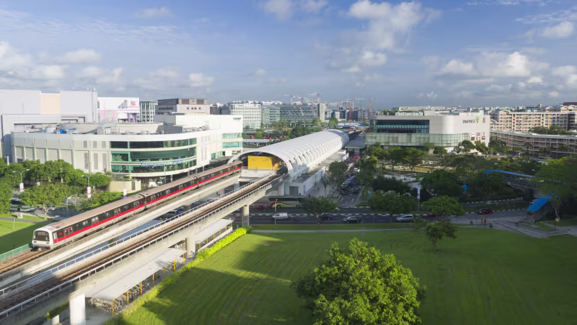
In contrast, most other parts of Singapore, even today, lack redundancy in their rail links. I could literally count all the towns with alternative train links with one hand! (Woodlands, Tampines, Bishan….I suppose Bedok if I were a bit loose with my standards)
And for those towns aren’t part of the aforementioned, living knowing a ticking time bomb that could disrupt numerous livelihood, is not reassuring. As the great derailment saga has taught us.
3. Public Transport Connections (Bus)
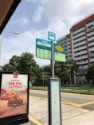
Tampines’ buses are another force to be reckoned with. For instance, their feeder services can compete head on with Toa Payoh’s frequencies! Be it during the quiet off-peak periods and sardine-packed peak periods. Pictured below is a random bus stop with the majority of Tampines Town’s feeders covering it.

With the exception of 296, 298 (BCEP routes seem to always produce undesirable headways), the feeders in Tampines run like well-oiled machines; operating like clock-work with little to find fault in.
And I haven’t even gone to the rather nifty thing most bus stops in Singapore have, that heavily alleviate the unpalatable long waits for a single bus service prevalent in other towns, and better manages crowds.
With the exception of the BTOs in Tampines North. ALL of the bus stops in Tampines have at least 2 bus services. And we are not talking about 2 feeders either bringing you to the same MRT station (cough cough Buangkok Crescent). The bare minimum I have seen would be 1 feeder, and one long feeder serving the same stop. That long feeder will come in handy for being a half-decent, competent travel alternative during MRT disruptions.

This is not the case in newer towns. What comes to mind are places like the Bricklands BTOs, located smack in the airy desert-like environment of Bukit Batok, often have bus services planned with the “it’s served” fallacy (coined by RMTransit), which feeder access is all you can expect. And the status quo is likely to remain that way with the BCEP essentially vindicating it as the norm.


Hell, even in matured estates, due to most towns being centered around the hub-and-spoke model, many such towns lack any feasible alternatives beyond the checklist feeder bus. Something I believe Tampines excels in.
In contrast, Tampines bus stops often have a long feeder or trunk in addition to the already frequent feeder. Some services that come to mind are 28, 72, 129, etc. Which greatly increases shortcuts around the MRT system, serving as yet another additional option for the daily commuter.

The town’s bus network isn’t flawless of course. It being ridiculously good, it suffers from its own success. Tampines Interchange is notorious for its miniscule size given the scale of bus services it holds, with buses queuing to board passengers frequently jamming the premises. And without any nearby reserved land surrounding the facility, the existing interchange simply could not be expanded. This necessitated the construction of the nearby Tampines Concourse Interchange.
Some services are also outrageously infrequent. 22, 39, 129 are some that come to mind. This is mainly due to operation limitations (lack of manpower, parking lots, deliberate route-cutting ahem 22). Hopefully, the currently planned Tampines Intergrated Transport Hub does not follow its predecessor’s footsteps of being undersized for expansions. It would certainly give more breathing room for the day-to-day operations.
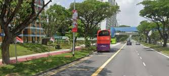
On the topic of buses, I would also bring up the fact a lot of Tampines’ arterial roads have bus lanes (e.g. Avenue 1 and 2) being part of LTA’s Transit Priority Corridor project. Better than certain towns that go without them (cough cough Punggol). But its too much of a vanity to be otherwise useful. Or worse, the plug could be pulled at any moment.
Otherwise, should bus irrationalisation be a vile scheme of the past, the town has a bus network worth flaunting and learning about.
4. Bicycle Infrastructure
Public Transport connections aside, Tampines actually is a rather half-decent town for active mobility; cycling! With previous Ministers of Parliament (MP) representing Tampines, such as Irene Ng, playing a key role in their advocacy.
Promoting cycling also benefits those who do not cycle. How? When residents ride the bicycle instead of driving a car, they reduce the number of cars on the road. This means less traffic, less parking problems, cleaner air and a greener environment for all.
~ Irene Ng, then-Member of Parliament (Tampines GRC)
In the town, it is commonplace to see people mounting their two-wheeled vehicle, be it electric-motorised ones, bike-sharing, or a good ole, rusted bicycle.
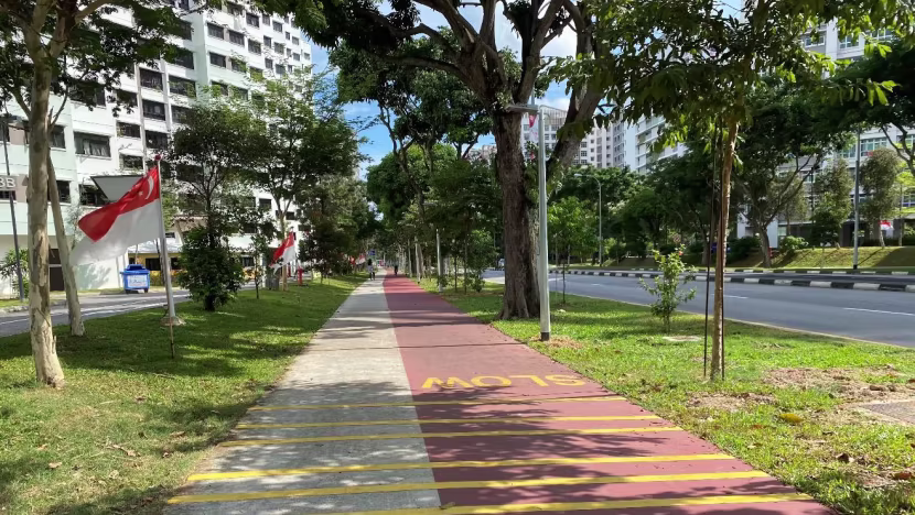
As food for thought on what I mean, just compare these paths side by side, you’ll feel that the paths in Tampines are a leg up over the other.
Take the paths listed below. Which are common occurences in other towns which the cycling paths are often shoehorned into the urban landscape.


If cycling paths weren’t planned in Silo, and ministers aren’t busy playing PR games, Singapore could at least reach Tampines Cycling lane standards.

While of course, Tampines isn’t immune to the half-baked trash paths, but due to the tangible political influence advocating for a certain standard for cycling paths, Tampines’ worst paths are not as bad as the neighbouring towns’ Hall of Shame. In my time cycling around the neighbourhood, most paths are consistently constructed as shown below.
And it doesn’t end with the present. Even future plans to expand the cycling network are in progress. One notable one that comes to mind is the path connecting Tampines and Simei under the existing MRT viaduct. This would bridge the gap existing car-centric infrastructure has separated for decades, more on car infrastructure later…

I do have a bone to pick with the current acceptable cycling path standards. They are too narrow and not grade-separated. But it is more of a National problem than East Side specific. So for now, I reckon the town does relatively fine for cycling.
5. Bonus: Amenities and Miscellaneous
Most transit planners overlook this, especially when it comes to LTA, considering the silly excuse of urban development being outside the juncture of land transport would likely play out. But this one thing while not written in our previous TbT posts, makes or break transit in a town.
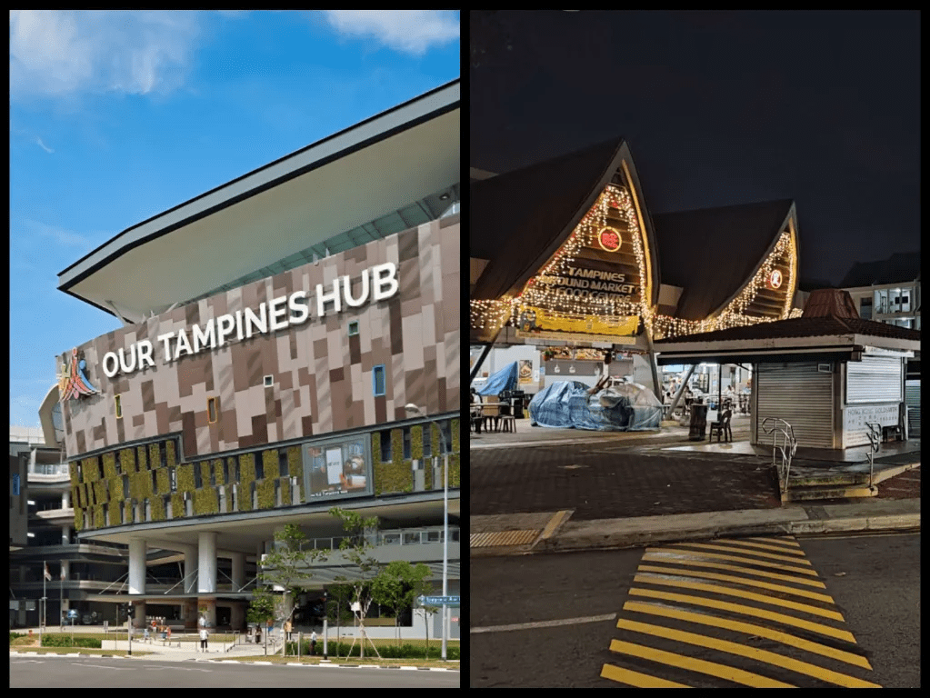
You see, in LTA’s current aspirations to achieve its “hub-and-spoke” vision, commercial developments are usually found in the center of each town; in this case; Our Tampines Hub. At first glance, it looks fine, until you think about it from a user’s perspective. Since most of the population in a town would not live near the “hub”, it would mean the majority will be forced to travel intertown to do their grocery runs, eat a meal, or do any basic human needs.
Thankfully, Tampines does not have this issue. While I slightly disagree with Our Tampines Hub at centralizing all the amenities. I should chime that the town is at least, providing adequate amenities and facilities scattered around the town.
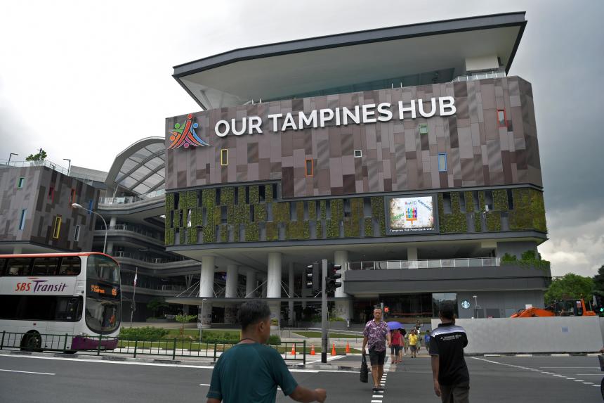
In the Central sector of Tampines, you of course you have the iconic Our Tampines Hub (OTH) Building, a building worth emulating apartt being an amenities hub. In this context, what is important is that OTH isn’t hard-carrying all of the town’s activities.
One can find sort of “town centre amenities” lying closer to residential estates. The downstairs coffeeshop, the nearby Tampines Round Market hawker centre, and shophouses everywhere lined up with all sorts of SME and retail/service businesses. Not to mention holding important faclities such as a SAFRA building (for now), and important educational institutes such as Temasek Polytechnic.


All in all, the good transport connections, the active mobility being taken seriously, scattered yet dense range of amenities, make Tampines an extremely desirable place for all walks of Singaporeans to live in. As the town comes close to the “20-45” dream we can only hope for decades later. There is no better way to tell Tampines’ desirability, than using Property Prices!
6. Addendum: Property Prices
In countries associated with car-dependency, such as the USA and Canada, it is often the pre-World War II built neighborhoods that have skyrocketing housing prices due to the wants of more and more North Americans wanting to live somewhere walkable. Moreover, the lack of new walkable homes being built due to such homes not complying with build Codes Of Practice causes a scarcity of such homes. As such, simple demand-supply graphs would tell you; be ready to stomach an eye-watering exorbitant price if you plan on living there.
Similarly, Tampines’ HDB units considered “matured” homes also face this issue. Their prices are much more asking than your run-of-the-mill HDB flats. Using a quick search on PropertyGuru, I can show you some wallet-crying prices of homes found in Tampines, compared to other parts of Singapore, such as dear Choa Chu Kang.
(DISCLAIMER: The STC is by no means, account or whatsoever qualified to explain property prices, and is made aware to many other factors that affect home prices. This this simply meant to be a quick experiment; food for thought for you readers)

Take the below example. In the “suburban” parts of each town (further from the town center), Tampines East vs Yew Tee. Both homes despite being a similar distance from a transit stop (MRT stations Yew Tee and Tampines East Respectively), both homes being in relatively good condition, and even sharing the same age (both were built in 1993 with a 99-year lease). We can see that the Tampines flat commands a noticeable premium, of about a $100,000 difference, which is pretty significant. One could purchase a used car with that kind of money.

So there we have it! Tampines really looks to be shaping up as the ideal poster-boy for urbanism, right???…….
7. Grass isn’t always green…
If any of this information has you sold that Tampines is the ideal godsent place to live in, I strongly advise ending your reading here. As much as I hate to say it, Tampines is by no means a perfect town, and has flaws closely shared with Yishun.
One thing I can never comprehend, is the fact the town has a ridiculous amount of expressways that surround and connect Tampines’ residential neighborhoods by private vehicles. Like how many lanes of fast travel do you need? Not one, not two, but technically three (!!) ways cars can take the high roads to and fro Tampines, which are built around the town.

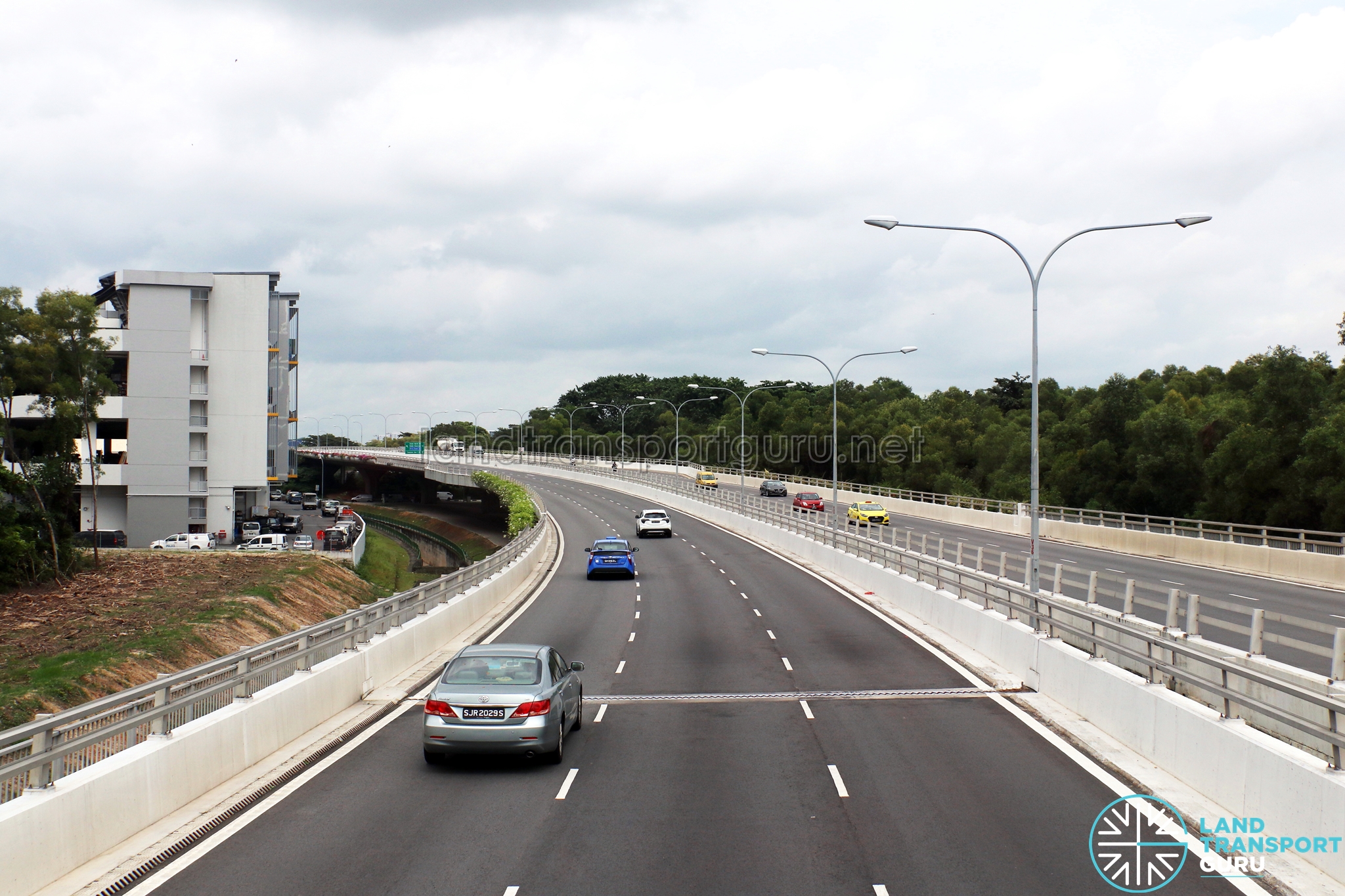
But with that being said, they aren’t necessarily a bad thing for Tampines. many of Tampines’ bus routes also use those highways, such as the TPE buses, 23 which uses the PIE and a bit of Bartley Road East, and so on. But having three of them is a testament politically and perceivably, that the powers insist on maintaining the unsustainable, unpalatable status quo of “the car is king”. Being the fastest for both inter- and intra-town travel. I can feel the Downs-Thomson Equilibrium already losing its balance, when cars can go too quickly. But rest assured, we have something in the works to address this come TM50.
But for now, leaving those lanes to their own devices will induce traffic, bottleneck the town eventually if nothing changes.
And let us not forget Tampines is home to some of the most car-centric destinations known in this country. places which are not strangers with free parking! Places designed to come by car, places which not having a private vehicle makes one an outlier.

If it wasn’t obvious, yes I am referring to The Tampines Retail Park (TRP), which houses some of Singapore’s few Big-Box stores. What is urbanism when the life of an American is literally a drive away? Sarcasm aside, I am glad that such building designs and locations are relegated as a minority. But its existence makes me need to dock off a few points from the town, adding to that, the Tampines Retail Park shuttle bus downsizes in 2023 that serves as another push factor to use a car….
While service 296 introduced does sort of alleviates the “TRP <-> Tampines Central” demand gap, it is painfully slow compared to the service it replaced. Not on par with private motorized transportation at all.
Now, to be fair to Tampines, all the problems relating to delegating excess infrastructure, land and asphalt devoted to private vehicles isn’t exclusive to it. Most towns in Singapore also do terribly in this regard, with countless road expansions (cough cough Pasir Ris), new roads (cough cough Punggol North Avenue), and big carparks in “car-lite” branded districts (Cough cough Tengah).
Lastly, having experienced it myself, car-brains. Especially those that fought for the bus-lane downgrade. This needs no explanation.
8. Summary
From an Urbanism and Transit perspective, we have no choice, but to concur to the long-running gag narrative. The East truly blitzes most other towns in terms of public transport, active mobility, and is one of the closest towns as the poster boy of Good Urbanism of Singapore, albeit not perfectly.
Some key points Tampines could do better are in:
- Better bus lanes, full-day bus lanes on the existing TPCs could go wonders
- The new Tampines ITH, it better be adequately sized to exceed the existing regional interchange.
- Bike lane network improvements, as well as the quality of the paths themselves
- Cutting back on the lanes. Road diets should be norm, rather than endless lane expansions done in the last decade.
- Notably, space for wider bike lanes can be taken from the wide avenues plastering the whole town.
For any aspiring urban planner, I personally think if there is one thing you should takeaway, is that new developments, or even existing ones, should be built to emulate as many of Tampines’ positive attributes, be it the good transit connections to the sane, human-scale urban environment to drag people out of car-dependency.
Join the conversation here, and don’t forget to press the like button! Thanks for reading oneSTC.

Leave a reply to To Build Abundance, Think Broad – SG Transport Critic Cancel reply