
It’s been nearly five years since the blog began discussing the various complexities of the Jurong Region Line, that light rail line in western Singapore serving as a key regional connector between the various hubs of activity in the west. With an extremely unique line profile, simultaneously featuring a three-way round robin and two distinct line segments intersecting at Tengah, the discourse around the JRL hasn’t died down, even as the JRL nears its initial completion stages set for 2027.
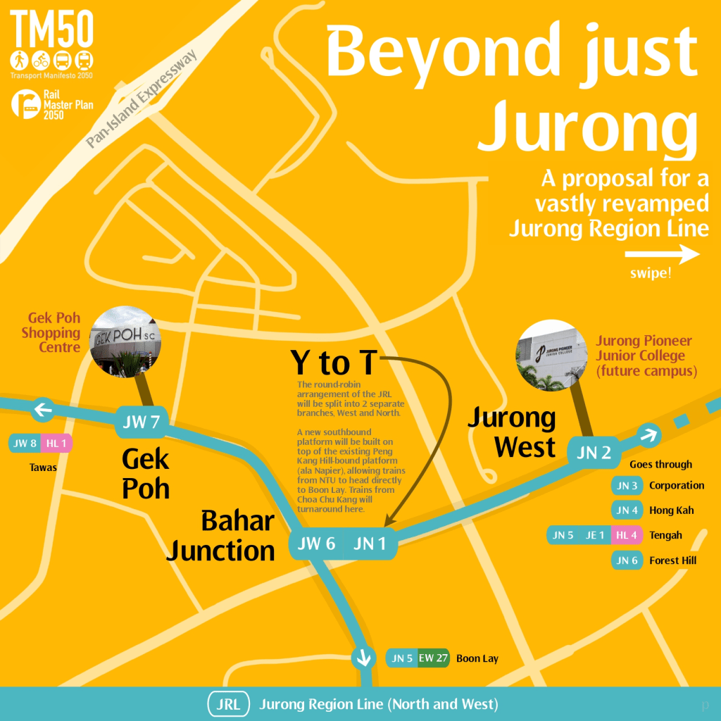
Over the years, various fixes and changes to the entire JRL system have been proposed from our end. Bahar Junction, that round-robin in Jurong West, should be converted into a simpler “T”-junction enabling bidirectional access on both line segments intersecting there. The JRL’s east branch to Jurong East can be rerouted to the JLD station to bridge the missing connection between the CRL and Jurong East (a connection whose absence discredits any suggestion of the CRL being a valid alternative to the EWL, in light of last year’s derailment). Said east branch, to better handle the higher demand there, can also be expanded to double-trainset formations to better serve the various commercial and industrial demand the new alignment is expected to receive. Earlier last year, I also proposed having the JRL take over the section of the Bukit Panjang APM between Choa Chu Kang and Bukit Panjang, to improve capacity along this corridor linking the northwest’s two major population centers.
With almost every piece of the puzzle in place, it is time to wrap up the full solution to resolving the JRL’s initial planning issues, the result of having been originally intended as an APM network, rather than full-fledged light rail. Consider this also an explanation piece for the proposed JRL Bukit Panjang extension from our Transport Manifesto 2050.
The only question that remains of the JRL, in light of that earlier proposal to replace parts of the BPAPM with it, is the question of how to extend the JRL to incorporate another line that it does not physically intersect. Furthermore, the NSL stands in the way between Choa Chu Kang West and the BPLRT, the single connection needed to fulfil the vision of a one-seat JRL ride from Tengah to Bukit Panjang. With Choa Chu Kang located significantly far from the path of a potential JRL extension, while simultaneously being the key secondary node of the northwest, it’s a lot more tricky to realise a partial conversion of the BPAPM (between Choa Chu Kang and Bukit Panjang) to JRL than otherwise assumed.
How then, can a JRL Bukit Panjang extension leap through both geographical challenges the mature Choa Chu Kang town poses, for it to be realised? The answer to one of them lies in the question itself.
The core challenge
Three facts should be prominently recalled. The first, is that the existing BPAPM as a linear connector between the NSL and DTL is sufficiently slow to the point where local buses (with NO signal priority, as is the case in Singapore) are capable of outrunning it.
The second, is that unlike the SPAPM, where a certain degree of APM-bus integration is maintained, BPAPM stations (along the linear stretch) are not located together with bus stops along the same road. Presumably this was done to reduce duplication, but that pretty much only makes sense in the context of a highly limited APM system intended as a mere feeder service.
Last but not least, the BPAPM was unfortunately, as a result of officially-acknowledged political pressures, built in a manner that by today’s civil engineering standards, would be considered… lackluster, in terms of ride quality delivered. The jokes around the BPAPM being the cheapest rollercoaster in Singapore have made sufficient rounds in the public consciousness, and it should be blatantly obvious that the JRL cannot, and should not be expected to become a mere steel-on-steel version of the present-day BPAPM.
The necessary conclusion one arrives at would be to demolish the linear segment of the Bukit Panjang APM, comprising the four stations between Choa Chu Kang and Bukit Panjang (excl. both), and start from scratch, but this time doing better. Additionally, given the larger scale of the trains used on the JRL relative to existing APMs, it makes sense, given the readily available bus services in the area (including but not limited to the BPLRT supplement 976), to reduce station count, while repositioning them to better enable connections to prominent bus services on the road below. This hardware replacement of the BPAPM’s Choa Chu Kang sector is not just favourable, but necessary for a JRL extension to really be a fast link from the DTL to the NSL and Tengah.
It’s not too difficult a choice anyway — the obvious survivors under a more stringent planning criteria are the Keat Hong and Teck Whye stations, both relocated to better position themselves, either in the tight turns the BPAPM was originally built into, or better serve community amenities and bus connections. Phoenix station, built a stone’s throw away from the Teck Whye and Ten Mile Junction stations, exemplifies the spirit of building stations for the sake of it (call it politicisation of transit planning if you will, which is also part of the “political pressure” behind the BPLRT’s conception). Local buses plying an identical route to the BPAPM on the surface unironically stop the same patterns, if not less, between the Keat Hong and Bukit Panjang stations! Any wonder why even local buses, without any additional bus priority, are able to outrun the APM?

Likewise, South View belongs in the bygone era of the BPAPM being the sole complementary rail link in the Choa Chu Kang area. With the JRL’s Choa Chu Kang West station a 5-minute walk away, and the JRL extending over the APM corridor, it makes sense, given the comprehensiveness of bus connections, for it to be consolidated with neighbouring Keat Hong. The removal of South View is also necessary to make possible the act of bridging the BPAPM and JRL legs together, such that a through Tengah – Bukit Panjang service may be realised within physical limitations that govern our world.
Quite literally, Tengah and Bukit Panjang will be bridged, by a “bridge” elevating the JRL above the NSL, up from current viaduct heights along both officially-planned JRL segments and the BPAPM. This is the reason why South View has to go — it’s too close to the NSL viaduct for the JRL to sufficiently elevate itself over the former. At Choa Chu Kang West, careful work will have to be done for the elevated bypass to climb over the NSL as it heads towards Bukit Panjang. To be honest, building this bypass without disrupting residents immediately around will prove a monumental challenge that, if completed, will be recognised as a significant engineering feat accomplished with severe constraints in working space. As far as possible, radical rail projects such as the JRL Bukit Panjang extension (and many more to come in the TM50’s Rail Master Plan) try not to involve overt land acquisition (which implies nasty things like forced eviction, demolition etc.). With a curve radius of 120m over the junction of Choa Chu Kang Ave 3 and Choa Chu Kang Way, this JRL extension would barely clear the narrow opening between closely-lined rows of HDB flats dating back to the 1990s, flying over the existing JRL and NSL viaducts to reach Bukit Panjang. Tough, but ultimately doable when afforded additional breathing space with newly-designed infrastructure on the Bukit Panjang extension segment.
Choa Chu Kang station, relative to all efforts to have the JRL take over part of the BPAPM, is located in a rather unique position. Located off the path between Tengah and Bukit Panjang, as is the desired connection the JRL BPe is supposed to fulfil, Choa Chu Kang station is a hub of its own, where significant passenger volumes flow to from the NSL, present BPAPM and the many buses at the nearby bus interchange. With a nearly even three-way split in demand between the three travel patterns expected around Choa Chu Kang, conventional branching or spur operations will inevitably inconvenience (and ultimately, irritate) a significant ridership base, regardless which direction it is carried out. (Even the current arrangement with the BPAPM, which forces a transfer at Choa Chu Kang to the JRL, is a significant inconvenience to passengers travelling between Tengah / Jurong West and Bukit Panjang, which is the motive for the JRL BPe in the first place!)
Given existing infrastructure at Choa Chu Kang (post-JRL), and the new link over the NSL proposed, it’s a hint for us to consider a strategy that, in its degraded form, is applied elsewhere in the current JRL plans.
What Bahar should have been
Bahar Junction, as a T-junction, should have stayed as such in the station’s design, and earlier posts here have referenced it as a solution to the convoluted round robin in current JRL plans. However, the concept of sending trains through three-way junctions, much as the Bahar Junction application was butchered terribly, remains relevant in situations where three-way demand is equally significant, particularly to serve a major node linking to the NSL, which remains the key rail line in Choa Chu Kang.
As a junction located between stations (rather than on one), having a three-way tie near Choa Chu Kang enables all three demand patterns to be matched with a corresponding JRL service pattern. On the same tracks, the service between Bahar Junction and Bukit Panjang would share tracks in part with the existing service pattern to Choa Chu Kang, and the BPAPM replacement service linking Choa Chu Kang to Bukit Panjang.
At Choa Chu Kang, little changes. Besides the reconstruction of the current APM station as a full-sized station accommodating JRL trains, things stay largely the same. Here, having two stations for the same line may sound ridiculous, but you can think of it as a crowd control measure to sieve passengers bound for either direction on the JRL (either towards Bukit Panjang or Tengah / Bahar Junction) into the corresponding station building.
Similar to the Fernvale line we proposed last month, branching is (counterintuitively) a core part of making the JRL BPe achieve its objectives of enabling more connections between multiple destinations in western Singapore. This is a rare case where the downsides of branching (ie worse frequency) may operate to the benefit of the new JRL. Where demand on all three services forming the tie is more or less similar, and when the JRL is a significant capacity upgrade over an APM line it partially replaces in Bukit Panjang, a three-way branch which fills up each other’s track capacity on the mainline means less downsides for more convenience. This means that even if each individual service pattern (namely Bahar – BP, Bahar – CCK, CCK – BP) operated trains at 5-minute headways, a subpar standard for the peak period, those travelling on the common sectors of the JRL will experience 2.5 minute intervals, in line with what’s expected on (most) other rail lines currently. And even with 5-minute intervals, the JRL still carries more passengers per hour than the BPAPM it replaces. (For what it’s worth, it was running 5-minute headways throughout the day not long ago anyway).
While we’re at it, it’s useful to highlight how the JRL conversion of the BPAPM would improve the commuting experience too. Presently, BPAPM stations are located on one side of the road (as a result of the projects hasty conception). This inconveniences residents living opposite these stations, who are faced with the double whammy of having to climb up to the elevated platforms, AND cross the road. While elevation is kind of inevitable for a grade-separated rail line, rebuilding Keat Hong and Teck Whye stations to JRL specifications allows for the viaduct (and the stations) to be repositioned above the road median, reducing access penalty for all. Such station designs (which are common even in Singapore, see Clementi and Canberra), enable more space to build escalators, the main workhorses of vertical circulation. For Teck Whye station, it also opens up the possibility of inserting linkways from concourse level directly into ITE College West, a key trip generator around that station. And it makes for a really fancy overhead bridge, a design typically integrated into road-spanning stations like Dover.
When complete, this proposed JRL (collectively recognised under the Manifesto’s Rail Master Plan 2050 as the North and West branches) would comprise a West line running between Peng Kang Hill (NTU) and Jurong Pier, and a North branch incorporating three-way services between Bahar Junction, Choa Chu Kang and Bukit Panjang, enabling better rail connectivity between many more areas in western Singapore.


Consider this not just as a proposal to improve the Jurong Region Line. Together, these changes (including the revamp of Bahar Junction station) make for stronger rail connections in western and northwestern Singapore, and for many, better service than they get currently. A more direct, and faster link between Tengah, Jurong West and the DTL / Bukit Timah Railway would be a significant plus in bridging the key population hubs with further-away rail lines, and if something of the likes of September 25 happen again, it might make DTL as an alternative for west side residents sound a tad more credible, even if it isn’t exactly so.
As big as Jurong is in the west, the demand for rail, even if it’s light rail, goes far beyond its size. The JRL, which already partially exists and is slated to open towards the end of the 2020s, has to step up and go beyond just Jurong, such that it may be valuable to even more Singaporeans. It’s the best candidate for such anyway, and comes with the added bonus of giving us a chance to fix mistakes of the past.
The case is convincingly clear: let’s extend the JRL to Bukit Panjang.
Interested in building a better future for Singapore’s transport? Join the STC community on Discord today!

Leave a comment